jazzeum
Four Star General
- Joined
- Apr 23, 2005
- Messages
- 38,386
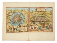
I came across these maps in doing some research and thought it might be of interest.
The map on the left depicts Tenochtitlán in the late 1500s, probably 1572. It is believed drawn by Georg Braun, a mapmaker who lived between 1541 and 1622. The map map come from the Civitates orbis terrarum, which contains maps of cities from all over the world.
The map on the right is Cuzco, Peru, believed drawn by Frans Hogenburg, a Flemish and German painter, engraver and mapmaker, who lived between 1535 and 1590. This map also probably came from the Civitates.


