mestell
Lieutenant Colonel
- Joined
- Feb 12, 2008
- Messages
- 7,997
After General Braddock’s disastrous defeat, the British frontier (northwestern Virginia, southwestern Maryland, and western Pennsylvania) was wide open to French and Indian incursions. Fort Cumberland, located in Maryland near the confluence of Will’s Creek and the North Branch of the Potomac River was essentially the only Crown fort available for the protection of the frontier. For the next three years Colonel Washington, Commander of the Virginia Provincial Regiment, would establish a series of forts in his attempt to defend Virginia against the French and their Indian allies.
Realizing the importance of a protected supply route from his headquarters at Winchester, Virginia to Fort Cumberland, Colonel Washington established a chain of forts for that purpose. These included Fort Loudoun, his headquarters at Winchester, Fort Edwards on the Great Cacapon River, Fort Pearsall on the South Branch of the Potomac River, and Fort Cocke, Fort Ashby and Fort Sellers on Patterson’s Creek. Fort Edwards and Fort Pearsall were fortified settlers’ homes which afforded security to the neighbors and a station for soldiers. Men of the Virginia Provincial Regiment built the other forts mentioned from scratch directly at Colonel Washington’s orders.
The “Provincial” built forts were stockades made of upright logs about 90 feet square, with either a blockhouse (Fort Cocke) or a diamond-shaped bastion (Fort Loudoun and Fort Ashby) at each corner. Between the corner defenses was a stockade wall about 12 feet high. Loopholes were cut into the wall for the firing of muskets. Inside each fort would be at least a barracks and a magazine. Generally 20 to 30 soldiers manned these forts. Swivel guns, 4-pounder and 6-pounder cannon were also available to bolster the defenses.
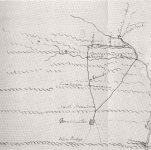
The picture provided is of a period map of the chain of forts described. The roads from Fort Loudoun at Winchester, Virginia to Fort Cumberland in Maryland have been enhanced. Going north from Winchester, squares represent the location of the forts in the following order; Edwards, Pearsall, Cocke, Ashby, Sellers (not shown but was near the confluence of Patterson Creek and the North Branch of the Potomac River) and then Fort Cumberland notated by a “star/cross”.
Later - Mike


